Breaking news
SAS 2016: Insitu moving forward with ViDAR payload integration on ScanEagle UAS.
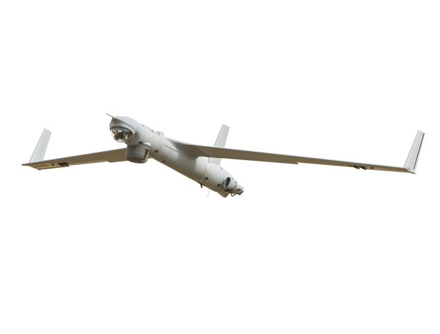
 Insitu's ScanEagle UAS fitted with ViDAR detection system (Credit: Insitu) |
|||
When equipped with
ViDAR, ScanEagle can search a 20-nautical-mile-wide swath of water and
detect objects that traditional maritime search sensors often miss,
such as low-profile semi-submersibles, marine mammals, and humans. Using
ViDAR and an existing turret, ScanEagle can search an approximately
13,360 square nautical mile area in 12 hours. The new payload can distinguishes
between water and objects based on pixel sensistivy, making it easier
for the operator to rapidly locate, track, and catalog multiple objects
of interest. Insitu started working on ViDAR payload in 2010. In late 2015, Insitu, Hood Tech Corp and SVS conducted successful maritime search, detect, and classify flight operations using a ViDAR-equipped ScanEagle from the Royal Australian Navy. Further developments will now focus on payload integration within Insitu GCS and information processing software, and utilization of an IR sensor for nighttime search capability. ViDAR is a wide area autonomous detection system for electro-optic imagery in the maritime domain. In addition to cueing ScanEagle’s primary camera turret, the payload gives operators who typically must rely on larger, more expensive aircraft to detect objects in the ocean a smaller, more cost-effective solution. The software that runs the ViDAR payload was developed in Australia by Sentient Vision Systems, and was built into a ScanEagle payload by Hood Technologies of Hood River, OR. Sentient and Insitu are pleased to confirm the signing of an exclusive global distribution agreement for the ViDAR software for unmanned systems within the small UAS weight class. ViDAR fits a modular slice on ScanEagle that comprises a large backplane digital video camera that continuously scans the ocean in a 180-degree arc in front of the air vehicle. Sentient’s ViDAR software then autonomously detects any object on the surface of the ocean, providing the ground control station with an image and location coordinate of each object detected in real time. The primary sensor can then be cross-cued to the object by simply clicking on the image. In demonstrations, ViDAR has autonomously detected a fishing vessel at 14 nm, a fast boat at more than 9 nm and even the spout of a whale at 1.5 nm from the aircraft. |
|||


