


Breaking news


Turkish Group Titra and Airbus Collaborate to Upgrade ALPiN Drone with DeckFinder Tech.
On May 24, 2024, at the SEDEC 2024 exhibition in Türkiye, it was announced that Airbus Helicopters is collaborating with the Turkish group Titra to integrate its innovative technology, "DeckFinder," into a helicopter drone, the Alpin. This system will enable automatic launch and recovery operations on ships, independent of maritime conditions and without the aid of satellite geolocation systems.
Follow Army Recognition on Google News at this link
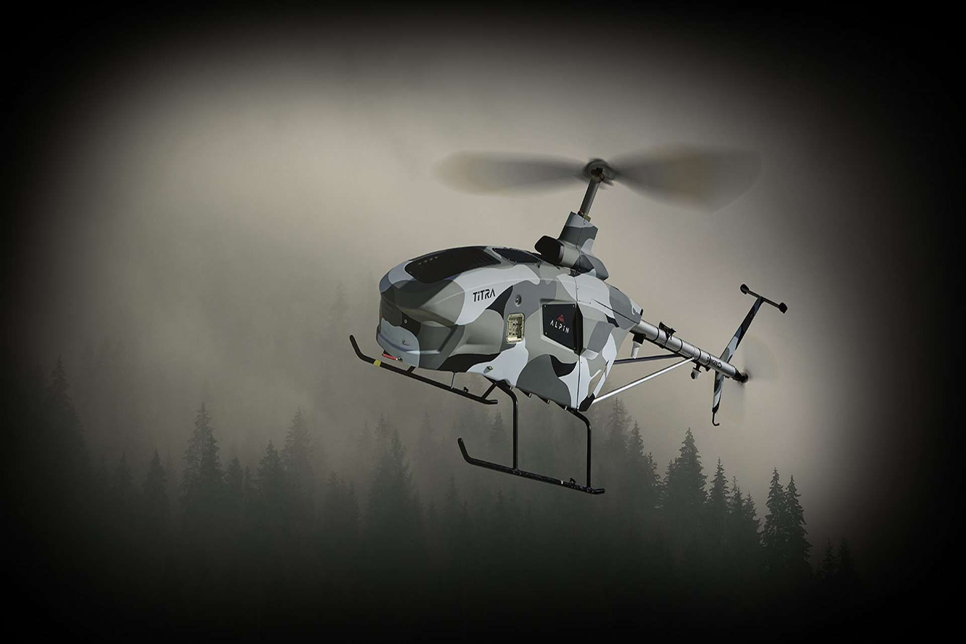
Titra Technology ALPiN Helicopter Unmanned Aerial Vehicle (Picture source: Titra Technology)
This new collaboration is part of the Aerial Drone System for the Navy program which is focused on developing technology that enables the automatic landing of helicopter drones on ships, a capability that has not yet been achieved at this level. This project could be integrated into NATO's efforts to enhance interoperability among the naval forces of its member countries. Key NATO nations such as the United States, the United Kingdom, France, and Italy, which have a strong interest in advanced drone technologies, could be involved. Türkiye's collaboration with Airbus highlights the potential for broader participation by NATO members, aiming to improve operational capabilities and cooperation in maritime defense technologies.
DeckFinder™ is a local positioning system that allows manned and remotely piloted aerial vehicles (RPAS) to determine their relative position in the harshest environmental conditions. The independent navigation system contributes to easier and safer take-off and landing procedures in GPS-shaded environments that lack reference points or visual cues.
When landing on small or moving helidecks, a difference of a few centimeters can compromise and endanger a whole mission. To avoid such risks, DeckFinder™ provides a three-dimensional image of the RPAS's relative position, aiding in safely landing the aerial vehicle.
DeckFinder is a high-end positioning sensor that supports naval operations by ensuring an elevated degree of positioning accuracy of more than 20 cm, especially during take-offs and landings. The system can handle dynamic situations with an update rate of 33 Hz and a scalable operation area of up to 300 meters. Its components are designed to perform optimally in harsh conditions: the rugged Ground Station Units are built to withstand extreme temperatures ranging from -32°C to +55°C, and the 1.6 kg airborne equipment can operate in saltwater environments.
DeckFinder's three segments work in triangulation. The Ground Segment includes the components installed on the landing spot, the Airborne Segment corresponds to components on the aerial vehicle itself, and the Monitoring and Software Control Segment consists of management software that updates the vehicle’s position on a flight display or the data interface. DeckFinder ground stations can be installed on any fixed or moving ground base.
DeckFinder operates with multilateral, independent RF-based ranging signals. Distance measurements are done on a proprietary measurement principle in a license-free RF band that is independent of the Global Navigation Satellite System (GNSS). This innovative technique serves to determine the range between the ground station antennae and the airborne segment antennae with a high degree of accuracy in a local area.
DeckFinder excels at aiding rotorcraft landings on moving ship decks, as during offshore operations. For landings involving a pitching and rolling ship deck, DeckFinder's system of reference points integrated on the ship deck itself provides a crucial advantage to safe navigation.
The ALPiN, developed by Titra Technology, is a high-tech unmanned helicopter designed for fully autonomous operations, capable of taking off and landing without human intervention. This unique platform is programmed to fly to predefined points, completing all missions with remarkable efficiency.
The ALPiN helicopter drone is an adaptation of the Italian CH7 from Heli-Sport. Weighing 340 kg empty, the ALPiN can carry a payload of 200 kg and has a range of 200 km with an endurance of 9 hours.
The ALPiN stands out for its ability to carry heavy loads and its vertical takeoff and landing capabilities. Its prolonged flight endurance makes it ideal for a variety of operations, including 24/7 surveillance thanks to its thermal and night vision cameras. It also offers the ability to "hover" to observe a fixed point or target, and a "pirouette" function for target tracking.
The potential applications of the ALPiN are extensive, including reconnaissance, surveillance, power line control, cargo transportation, mapping, emergency base stations, disaster response, search and rescue operations, agricultural spraying, and radio/communication relays, among others.
The ALPiN is equipped with a Mode A/C/S transponder system, with options for air-to-air and air-to-ground communication systems, as well as real-time image and video transmission. Its integration with a GNSS Antijam system further enhances its robustness in disrupted environments.
Performance characteristics of the ALPiN include a service ceiling of 6,400 meters and a maximum airspeed of 203 km/h, with a navigation speed of 107 km/h. It operates on gasoline with a fuel capacity of 175 liters and can withstand winds up to 37 km/h. Its maximum payload is 200 kg with a maximum takeoff weight of 550 kg.
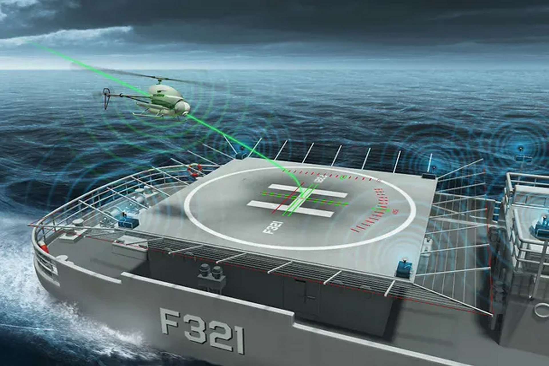
Airbus DeckFinder Technology (Picture Source: Airbus)